Atlantis Beneath the Ice (4 page)
Read Atlantis Beneath the Ice Online
Authors: Rand Flem-Ath
Let me congratulate you on the work you have done!
Sincerely,
(signed)
Charles H. Hapgood.
9
A week later a copy of
Maps of the Ancient Sea Kings
arrived. Far from dampening our enthusiasm for the idea that Antarctica may have once been Atlantis, the book had the opposite effect. We concluded that the ancient maps of subglacial Antarctica provided stunning evidence in support of our theory.
After the publication of the first edition of
When the Sky Fell
in January 1995, we returned to the Piri Reis map with two purposes in mind. First, to determine if there were grounds to support Mallery and Hapgood’s claim that the source maps used in the construction of the Piri Reis map were hundreds of years older than the 1513 date of its construction. And, second, to discover where these source maps, if they still existed, might be today.
SOURCES FOR THE PIRI REIS MAP:
HOW OLD?
Hapgood and his students found to their surprise that this ancient map, which should have been full of errors, was remarkably accurate. It possessed a standard of technical excellence beyond what Europeans could have achieved in 1513.
It wasn’t until the 1730s, when John Harrison invented and perfected the marine chronometer, a highly sophisticated mechanical clock, that determining longitude at sea was even possible. The incredible mechanical obstacles that the chronometer’s inventor had to overcome are documented in Dava Sobel’s
Longitude.
10
One of the oddities about the Piri Reis map was that it had been drawn using an extremely sophisticated projection. An “equidistant projection” depicts the features of the earth from a single point on its surface. This projection can be calculated from any spot on the globe. Perhaps the most familiar equidistant projection is the blue and white flag of the United Nations, centered on the North Pole. To draft a map using this method requires advanced mathematics, instrumentation, and knowledge unrealized by the Europeans of 1513.
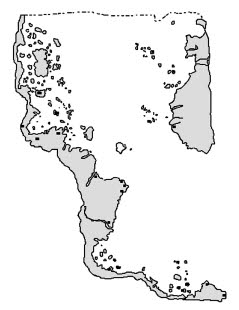
Figure 1.1.
Twenty-four points on the 1513 Piri Reis map are accurate within one-half of a degree of longitude. This level of longitudinal accuracy wasn’t achieved by Europeans for more than two centuries after the time of Piri Reis.
The equidistant projection was one that was very familiar to the cartographic staff of the Strategic Air Command at Westover Air Force Base in Massachusetts. It was used to target Soviet military and economic assets. For example, a map drawn using Moscow as its center allowed the military to calculate the quickest delivery time for a missile to travel from any NATO base to the Soviet capital. In November 1962, when Soviet missiles were introduced to Cuba, an equidistant projection map centered on Castro’s island revealed in terrifying detail how much United States territory could be targeted. Hence, the Cuban missile crisis.
Charles Hapgood explained to Arch C. Gerlach (chief of the Map Division at the Library of Congress) that the Piri Reis map “required
more astronomy than was known in the Renaissance. The mathematics require that whoever constructed it had to know the linear distance from Syene to the North Pole to within a degree of accuracy. Piri Reis did not know that, neither did Columbus.”
11
Mallery and Hapgood, as well as the U.S. Navy and Air Force experts, had become convinced by their exhaustive studies that the Piri Reis map offered compelling evidence that an unknown ancient civilization possessed advanced astronomical and geodesic knowledge.
SYENE OR THE TROPIC OF CANCER?
Hapgood and his students (notably Frank Ryan) spent months trying to determine the exact center of the Piri Reis Map. At first, Hapgood was convinced that it was the city of Syene, where Eratosthenes, the librarian and father of geography, had made his famous calculations about the size of the earth. Hapgood submitted this suggestion to the cartographic crew at Westover Air Force Base. Captain Burroughs concurred. He wrote, “Piri Reis’ use of the portolano projection
b
(centered on Syene, Egypt) was an excellent choice.”
12
We see in
figure 1.2
on page 22 how the complete map must have looked, based on the same projection used by Piri Reis in 1513. The chart Christopher Columbus carried on his voyage would have resembled this projection.
Despite the fact that professionals had verified Syene as the center of the map, Hapgood remained skeptical. He thought that the ancients would have been more likely to use the Tropic of Cancer, which divides the tropical from the temperate climatic zones. Hapgood was certain that such an important global marker would have been highly significant to the ancient navigators.
Figure 1.2.
The 1513 Piri Reis projection is but a fragment of the secret map that Columbus may have possessed. If the lost map is ever found, it should depict the entire globe using an equidistant projection centered on the ancient Egyptian city of Syene. Drawing by Rand Flem-Ath and Rose Flem-Ath.
Today, the Tropic of Cancer lies near Syene but not precisely over it. The difference in distance is small, but Hapgood and his students wanted to be exact in their calculations. There was considerable debate whether to use the measurement from the ancient city or from the climatic marker. Hapgood mistakenly assumed that it had to be an either/or choice between Syene or the Tropic of Cancer. It was a false choice. There was a time when the Tropic of Cancer lay directly over Syene. We believe that a clue to that synchronicity of time and place lies within the very projection of the Piri Reis Map.
13
When did the Tropic of Cancer and Syene share exactly the same latitude? Astronomers have concluded that it takes a century for the Tropic of Cancer to drift 40 seconds of latitude. This gives us a formula for our calculations and enables us to bull’s-eye the date when the original mapmakers were at work. By calculating the difference in distance
from the latitude of today’s Tropic of Cancer (23°27' N) to that of Syene (24°05'30" N), we discover the answer: about 5,775 years ago, that is, circa 3763 BCE.
Syene is 38 minutes and 30 seconds from today’s Tropic of Cancer. This is 2,280 seconds (multiplying 38 times 60 to convert minutes to seconds) plus the 30 seconds to give us a total of 2,310 seconds difference. We then divide these seconds by 40 to find that Syene was last on the Tropic of Cancer some 57.75 centuries ago.
The projection of the Piri Reis map points like an arrow at a pivotal turning point in human history. Archaeology teaches that Egyptian civilization dawned circa 3800 BCE.
c
THE SECOND
SANTA MARIA
Hapgood feared that the Spanish authorities would not take up the president’s challenge to locate the source maps that Columbus had used to chart his trip to the New World. After all, they had no motive to rewrite history since they were content with its outcome—Spain had discovered America. To overcome this problem Hapgood drafted a letter for President Eisenhower to send to General Francisco Franco, Spain’s fascist leader.
DRAFT PROPOSAL
A Letter from the President to General Franco
Dear General,
I have the honor to request your kind cooperation in securing an item of information of equal importance to the peoples and historians of Spain and the United States, relating to the discovery of America.
It is a question of a map, said to be the map of Columbus, which was seen by an American geographer on board the flagship of the Spanish fleet that visited the Columbian Exposition in the year 1893.
The Spanish fleet consisted of three ships, which were exact replicas of Columbus’ ships. The flagship was, therefore, named
The Santa Maria.
I enclose a copy of a memorandum from one of our historians explaining in detail why we think it important to find the “Columbus map” that was on board the replica of the Santa Maria that summer (in 1893). I also enclose a statement by the gentleman (now 89 years old) who saw the map on the Santa Maria and some related documents.
If it would not be a matter of inconvenience, we would greatly appreciate a facsimile copy of the map, which, we presume, must now be found in your archives.
Professor Hapgood’s memorandum and the supporting statement from our Col. Ohlmeyer will make clear, I am sure, the very remarkable importance that may be attached to this map.
With all personal good wishes,
(signed)
DWIGHT D. EISENHOWER
Enclosures:
1. Mr. Hapgood’s Memorandum
2. Mr. Campbell’s Statement
3. Col. Ohlmeyer’s Statement
4. Photograph of the Piri Reis Map
Included with the letter was James Hunter Campbell’s (1873–1962) account of his sighting of the elusive map. Campbell was only nineteen years old in the summer of 1893 when he accompanied his father to see the replica of the
Santa Maria
while it was docked in Toronto on its way to the World’s Columbian Exposition (the Chicago World’s Fair), held to celebrate the four hundredth anniversary of Christopher Columbus’s arrival in America.
STATEMENT OF JAMES H. CAMPBELL OF OCEAN BLUFF, MASSACHUSETTS, REGARDING THE COLUMBUS MAP HE SAW ON THE REPLICA OF THE
SANTA MARIA,
IN 1893:
The Spanish Government built and sent over to this country for exhibition at the Columbian Exhibition at Chicago, three replicas of Columbus’ vessels. There was the Santa Maria, which was the largest of the three; then there was the Pinta, and I think the third one was the Nina. They came to Chicago by way of the St. Lawrence River and the Great Lakes, and as they were passing through Lake Ontario they stopped at Toronto. My brother, who was on the reception committee of the Royal Canadian Yacht Club, met the officers and they made him promise that when he went to Chicago to see the Fair that he would call on them. The Fair was open for six months, and as near as I can remember my brother came to Chicago about the end of July or the first of August. My father was living in Chicago at the time, and was employed by one of the publishing houses.
When my brother came to Chicago to visit the Exhibition my father and I went along with him, as he was going to pay a visit to the officers of the caravels.
The caravels were tied up alongside of the Agricultural Building and right next to the boathouse of the Electrical Launch and Navigation Co. Since I was in charge of the electrical launches I was able to guide them directly to the caravels.
We went aboard the
Santa Maria,
and my brother introduced my father and me to the officers. When the officers learned that my father was a geographer and the author and publisher of geographies and other school books in Canada, they became much interested, and asked my dad if he would like to see Columbus’s map. Up to this time my dad
had left the conversation to my brother and me, but after that the conversation was carried on between the officers and my dad, and what made it worse when the Spaniards were at a loss to find words in English to express their thoughts, my dad invited them to speak in French, and to their surprise they found out a little later that my dad could also speak Spanish, so that cut out both my brother and me out of the conversation for the remainder of the visit.
The officers invited us into the Chart Room, and took out a large map. As I remember it now it was about four feet square. It covered most of the table that was situated in the center of the Chart Room. My dad was very short sighted, so he pored over the chart with his nose almost touching the paper. He was tremendously pleased, but he didn’t say much, until we got home again, and then he said he had difficulty in reading the map, not in understanding the language as he was a Spanish scholar and had at one time published a Spanish journal, and he also understood navigation, but he said he didn’t have enough time to study the map. Nevertheless he was overjoyed at having seen it. I might add that my father was an enthusiastic yachtsman, and at one time contemplated making a trip around the world in his yacht, the
Oriole. . . .
I am sorry I don’t remember the names of the officers who showed us the map, but it is most likely that they signed the log at the Clubhouse, and this has probably been preserved.
14