Women of Intelligence: Winning the Second World War with Air Photos (39 page)
Read Women of Intelligence: Winning the Second World War with Air Photos Online
Authors: Christine Halsall
The construction of airfields was a top priority as soon as a beachhead was established. In the months before the invasion, Medmenham PIs identified suitable sites from air photographs where airstrips could be quickly set up. In addition, an estimation of the enemy’s air strength was made from coverage of all the Luftwaffe bases in France. Just two days after the invasion, Allied aircraft were operating from airstrips built since D-Day, and within three weeks thirty-one squadrons were able to transfer to airfields built in north-west France. By 12 June the Mulberry harbours were constructed and operational. The Communications Section had produced comprehensive and updated reports on all transport routes leading to Normandy. In the early months of 1944, an Allied systematic bombing campaign started, which destroyed much of the means by which the enemy could reinforce the area.
The first Normandy terrain models were started late in 1942 and built on a scale of 1:25,000, about 5 miles to 1ft of model, showing the pattern of rivers, roads, railways and towns. These were soon followed by an order for a single model of the entire Normandy coast and going a few miles inland, on a scale of 1:5,000, about 1 mile to 1ft, which included the finest possible detail for combat briefing. It became the largest and most accurate model in military history. Every road, path or track had to be painted in by hand to a precise width and colour, complete with hedge-rows, trees, houses and other buildings, all copied in detail from air photographs. It took the model makers eighteen months to build and the work on its construction had to be fitted around all the other requirements for current operational demands. These included models for the V-weapons search and for specific D-Day operations such as the model for Pegasus Bridge, the site of the first glider landings in Normandy.
4
While the Americans made the models for their invasion beaches, Utah and Omaha, the British modellers worked on those for the British and Canadian forces: Gold, Juno and Sword. Each section of the main model was built on a standard wooden base, approximately 4ft by 3ft, which could be fitted firmly together to be viewed as a whole by tightening the clamps underneath. A young model maker was usually detailed to fulfil this task and one day Mary Harrison was busy clamping under the table when an extra-large number of high-ranking visitors arrived and crowded round the table to view the model. Her exit was barred by a forest of legs and she started pushing legs and pulling trousers to escape. Eventually a space cleared and a somewhat dishevelled Mary emerged to find herself in front of the Commander-in-Chief Bomber Command.
Bomber Harris looked down at me as I emerged and said, ‘And what did you do in Civvy Street?’
I replied, ‘I was an art student’.
To which Bomber replied, ‘Oh well, that explains it!’
5
By a stroke of genius the Section discovered a way to reproduce the individual plaster models, which a limited number of men could be briefed on, into a sturdy, transportable form using a mouldable latex substance. These were unbreakable and small enough to be referred to in the field.
When she heard of the invasion on 6 June, Mary wrote in her diary: ‘Invasion of France. I felt cold when I heard the news and wondered if either of the boys [her brothers] were in it.’ The following day: ‘A twelve hour shift and it seems like the longest day ever.’ Three days later: ‘Saw some invasion photos today and how they connected up with our work.’
The troops viewing a model of the scene they would encounter as they left their landing craft on the Normandy beaches would memorise the distinctive landmarks, such as a house with dormer windows or the shape of a church tower, in order to orientate themselves quickly. Specially printed maps, known as the ‘Bigot’ series, at a scale of 1:25,000 and overprinted with complete details of the German defence system and topography of the area, were issued to all units prior to the invasion. In addition, each platoon commander, in charge of approximately thirty men, carried a map of his sector of responsibility with landmarks marked. The Photogrammetric Section worked non-stop on preparing and supplying large-scale maps and plans of individual towns and villages in France, Belgium and Germany in support of the invasion. The speed of map production and delivery was a crucial factor in maintaining the continuity of the Allied forces’ advance. The section set up a 24-hour turnaround service from the receipt of a map request at RAF Nuneham Park, to the delivery to the commander in the field somewhere in Europe. This incredibly short period of time included finding and enlarging the relevant photographic cover, possibly of some obscure village the troops were planning to attack the following day, then fine drawing and annotation by hand, followed by quantity machine reproduction. Lastly, transport by truck and aircraft delivered the maps to the field unit that had placed the order. The work for the three Cambridge friends, Sophie, Lucia and Ena, required great concentration and meticulous attention to detail. There was no leave and they did not find any time for off-duty activities: ‘We all just wanted to win the war as soon as possible.’
6
With all the planning and preparations going ahead, the big question remained: where and when would the invasion take place? The ‘when’ was decided at the Teheran ‘Big Three’ conference in November 1943, when Stalin pressed for a Western second front to relieve the pressure on Russia. For years Hitler had considered that the Allies would strike in Normandy, while his senior officers were convinced that the attack would be made across the narrowest part of the English Channel to the Pas de Calais. Many inventive Allied deceptions were put into place to support the latter belief, including a bogus British army equipped with rubber tanks in south-east England, designed to provide German reconnaissance aircraft with evidence of a military build-up in that area. In the spring of 1944 Hitler changed his mind and a significant part of the German forces was retained in the Calais area, far from the Normandy beaches where the invasion actually took place.
One of the vital tasks undertaken by air reconnaissance in the preparations for D-Day was to locate all the enemy radar installations, in order to protect the invasion fleet as it crossed the Channel from its bases in southern England. In 1944 the enemy had increased the scope and density of its radar network in northern France by erecting many new stations in anticipation of an invasion. The Wireless and Radar Section at Medmenham undertook this interpretation work and produced very detailed target material of every type for existing radar stations along the Channel coast of France, from the Belgian frontier in the north-east to beyond St Malo in the west and stretching 20 miles inland. In the last two weeks of May 1944 Allied air forces carried out attacks on radar sites all along the Channel coast and destroyed almost all of them – but deliberately left some to function normally. These were to be utilised to ensure that the enemy picked up the signals of a large invasion force heading for the Calais area – except that this was another Allied deception. On 6 June a squadron of bombers flew at a specified speed along the Channel dropping ‘window’, strips of silver foil, at regular intervals, producing the same readings on the few surviving enemy radar detectors as a flotilla of ships.
Pat Peat recalled the evening of 5 June:
We stood outside our hut and heard and saw the planes towing gliders going overhead very low. The planes had no doors and they were flying so low that we could hear the men in the gliders talking to one another.
7
Elspeth Macalister also remembered that time:
The time leading up to D-Day was exciting and I remember the morning of 6th – wave after wave of gliders going over to France. Two days before, I was cycling up from Henley to Medmenham and could not cross the main road because of all the Army vehicles, tanks and all sorts trundling past, hour after hour, making their way down to the embarkation ports.
8
Over 8.5 million photographs were produced for the D-Day preparations alone and similar quantities would be extensively used throughout the Allied advance across north-west Europe. The non-stop processing, the accurate plotting and long hours of patient PI examination of air photography played a substantial part in the success of the Normandy invasion, the advance to Berlin and victory in Europe.
Jeanne Adams wrote about her experience of D-Day:
I had a rare insight into the preparations for the D-Day landings. My unit had been busy examining photographs of the Normandy coast, looking at ports, beaches, harbours and estuaries for suitable landing areas for the invasion. However, despite my work, I was still unprepared for what happened on 6 June 1944.
On the evening of 5th June, I was relaxing with friends at the Compleat Angler Hotel in nearby Marlow. We were having a drink on the lawn. As we stood there, a strange whooshing, rumbling noise began. A huge bomber plane was above us, towing a glider. It was flying very low – so low that we could see the pilot.
There was a strong smell of petrol as the sky began to fill with planes and gliders, all heading for the South Coast and then for Normandy. Security was tight at Medmenham and none of us knew what was going to happen. But on June 5th we knew that D-Day was upon us and that the invasion was about to begin. All those days and nights we had spent poring over the photographs – this is what it had all been for. Every beach, every port and every cliff on the Normandy coast had been plotted and modelled by us and here it was at last!
It was the invasion that I like to think was the beginning of the end of the war. I shall never, ever, forget that evening.
9
As plans and preparations for D-Day advanced and the bombing offensive continued against enemy industries, a new threat to the Allies emerged. It was a threat so grave that it could have caused the postponement of the Normandy invasion and possibly an evacuation of London. The German V-weapons (
Vergeltungswaffen
, meaning vengeance weapons) were missiles of previously unknown design, fired indiscriminately on the civilian population of southern England, and London in particular. In the early hours of 13 June 1944, just six days after Allied forces successfully invaded Normandy, the first V-weapon fell at Swanscombe in north-west Kent; people living nearby were puzzled that they heard a bomb explode yet did not hear the sound of a plane.
Since 1930 German scientists had developed totally new weapons, including a pilotless jet-propelled aircraft and a long-range ballistic missile. In 1935, an experimental testing base was set up near a small fishing village called Peenemunde, on the Baltic Sea island of Usedom. It was a quiet place with sand dunes and dense forests that concealed the workshops built alongside launch stands for experimental rocket tests, a runway to test fly new aircraft and a factory that produced liquid oxygen to fuel the rockets.
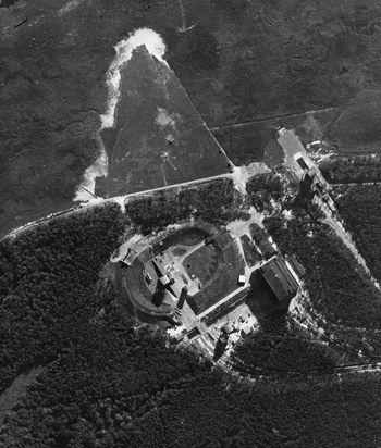
Air photograph of the experimental ballistic missile site at Peenemunde on the Baltic coast of Germany.
The V-weapons story could have come from the pages of a spy thriller in a race against time, except that these were real events happening to London, whose population became the first in the world to be attacked by weapons of mass destruction. Hitler referred to ‘secret weapons’ in a speech made in 1939 when war was declared, and a few months later an anonymous package, left at the British Embassy in Oslo, warned of German long-range weapon developments at Peenemunde. Little interest was taken, however, and the whole thing was put down to an enemy hoax and filed away. In May 1942, Peenemunde was photographed from the air for the first time by a PR pilot who, on his way to another target, by chance noticed some heavy construction work on the beach and took a short run of film. These photographs were regarded as ‘interesting’ at Medmenham, but the poor quality and small scale meant that they did not take priority over more urgent targets and were sent to the library. Unbeknown to the Allies, by the end of 1942 the first successful launches of a V-2 rocket and a V-1 flying bomb had taken place at Peenemunde.
Early in 1943, more hints of rocket weapon research on the Baltic coast came from a Swedish traveller and the Polish underground. Then a recorded conversation between two German generals being held as prisoners of war at a British interrogation centre mentioned rockets; the generals expressed surprise that none had yet fallen on England. This did raise alarm bells in intelligence circles and the Army Section at Medmenham was instructed to look for any rails or scaffolding that might be linked to an enemy long-range projector capable of firing from the French coast. More PR flights were made and the PIs worked on trying to make sense of the large embankments and circular earthworks at Peenemunde seen under their stereoscopes, but nothing resembled a projector. Their report did, however, lead to an investigation into the rocket weapon threat being set up under the leadership of Mr Duncan Sandys from the Ministry of Supply and Winston Churchill’s son-in-law.